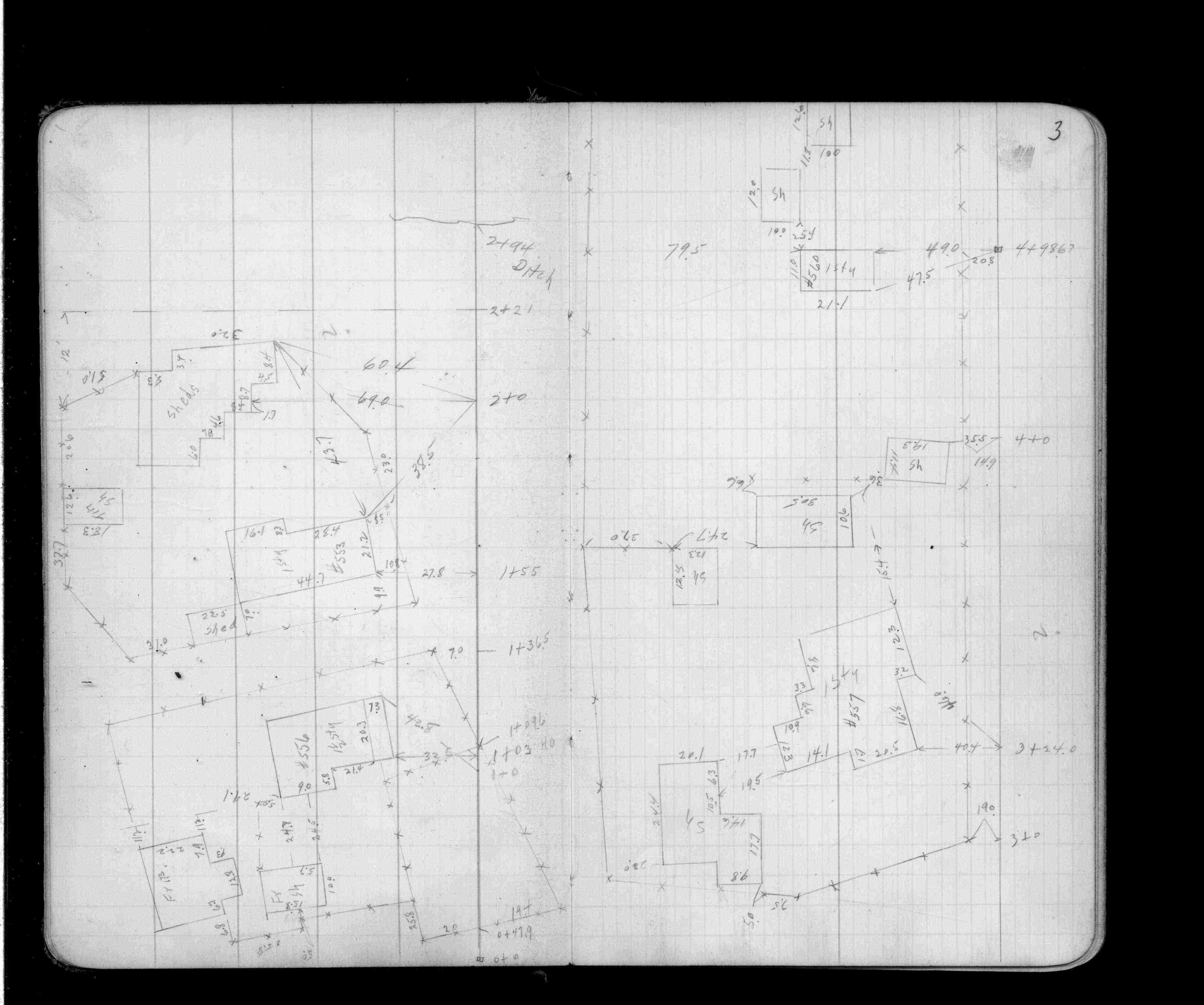
Page(s) 1-4
St Lawrence & Wisconsin Sts (Vac)
| Loc Levee Line | 0000-00-00
1
2
3
4
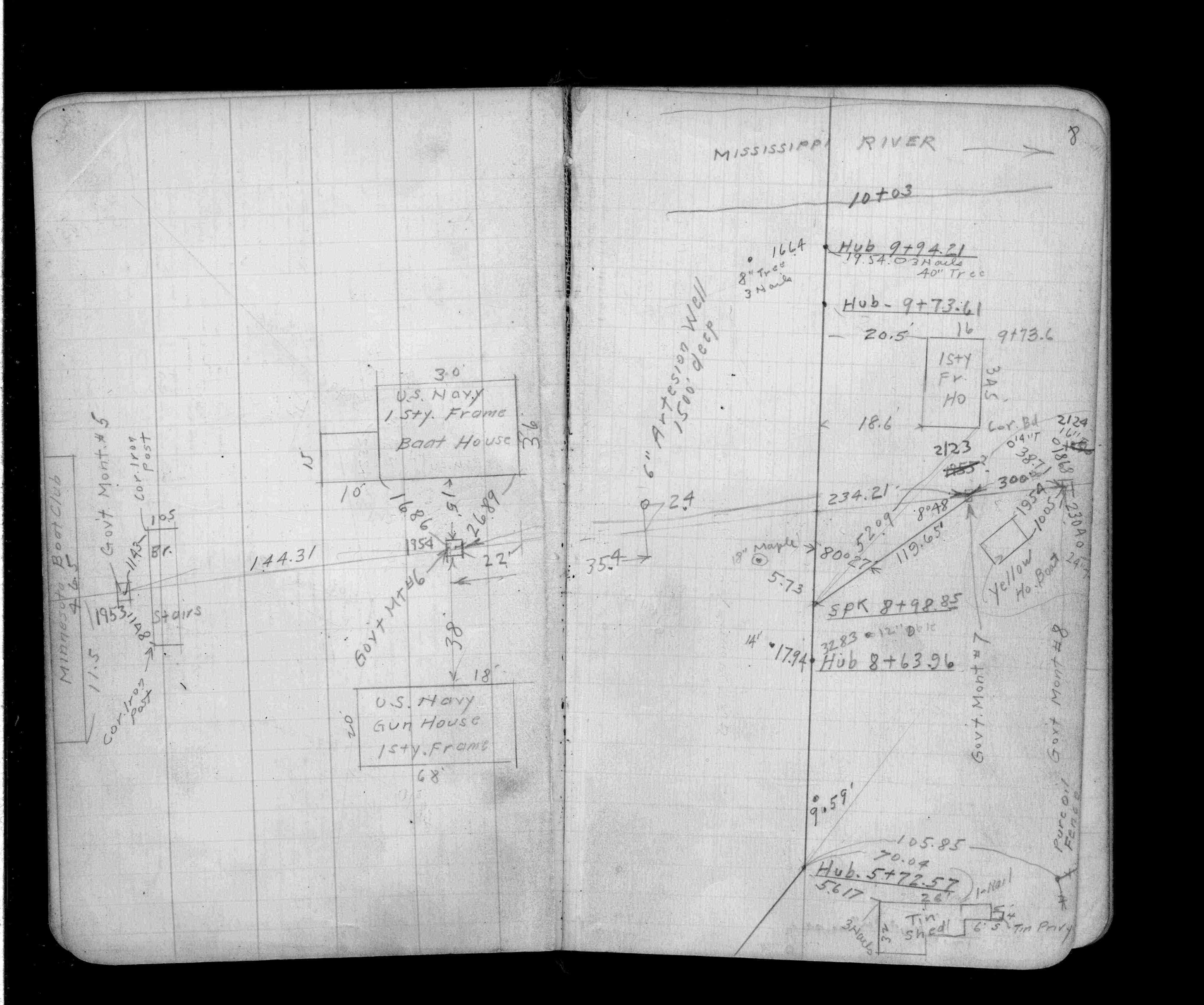
Page(s) 5-9
40 Ft S of "A" Line
FROM
Station 8+16
TO
Mississippi River(Sta 9+94.21)
| Locations | 0000-00-00
5
6
7
8
9
Page(s) 10
Line 40 Ft W of WL Missouri St
FROM
St Lawrence St (Vac)
TO
Mississippi River Edge
| Levels | 1945-04-18
10
Page(s) 11
Court St (Vacated)
FROM
St Lawrence (Vac) & Missouri (Vac)
TO
St Lawrence St
| Levels | 0000-00-00
11
Page(s) 12
Blank Page
FROM
Blank
TO
Blank
| Blank | 0000-00-00
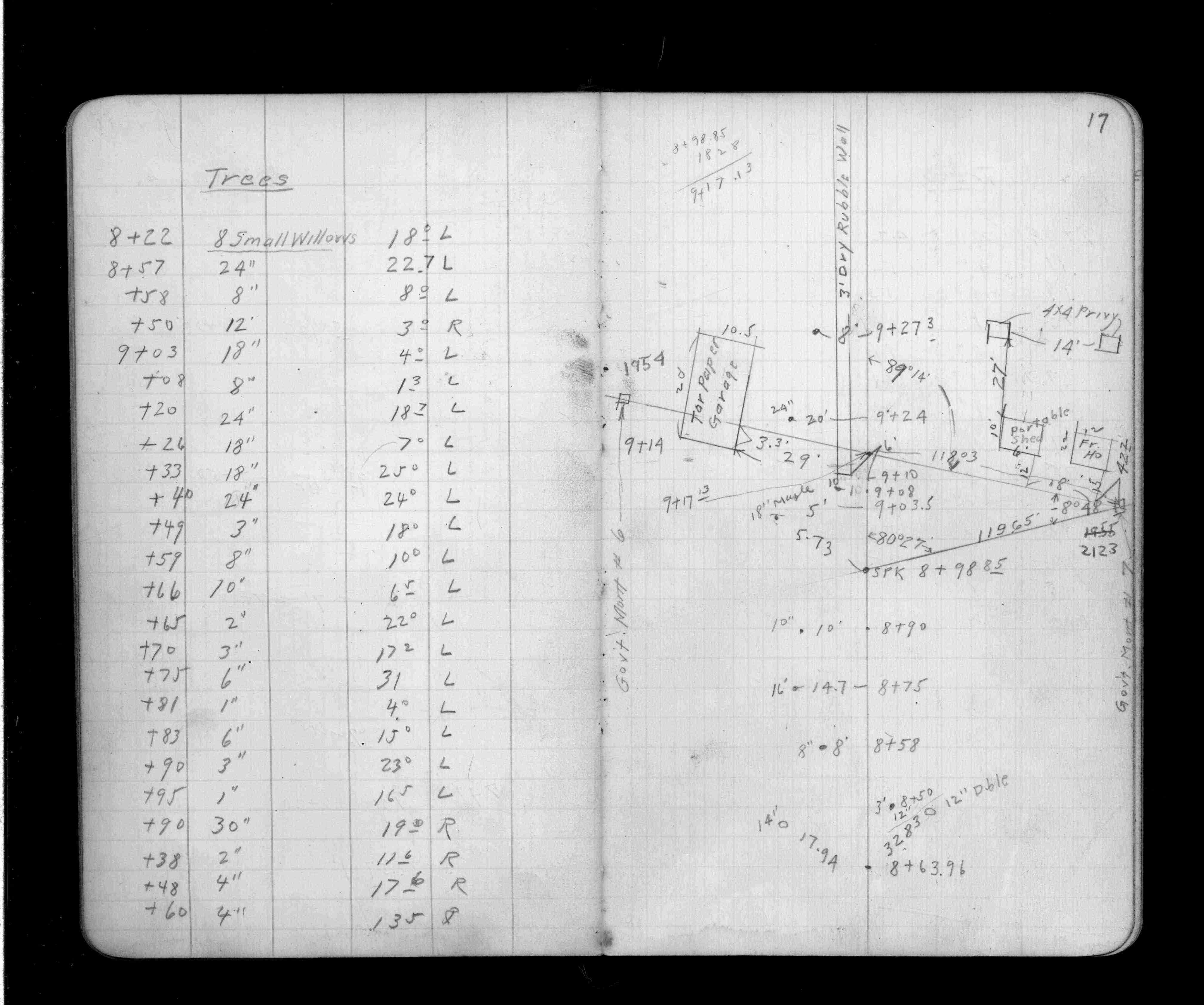
Page(s) 13-20
Levee Line
FROM
Water St
TO
Pure Oil Co Fence
| Locations | 0000-00-00
13
14
15
16
17
18
19
20
Page(s) 21-31
Mississippi River
FROM
Hub 15+00
TO
Station 14+56
| Cave Location | 0000-00-00
21
22
23
24
25
26
27
28
29
30
31
Page(s) 32
Mississippi River
FROM
Station 10+25
TO
Station 4+38
| Not Given | 1935-11-21
32
Page(s) 33
Blank Page
FROM
Blank
TO
Blank
| Blank | 0000-00-00
Page(s) 34
Phalen Creek Sewer Outlet
FROM
Double Barrel Sewer
TO
Station 181.8
| Locations | 1935-10-00
34
Page(s) 35
Page Voided
FROM
Void
TO
Void
| Void | 0000-00-00
35
Page(s) 36-37
Broadway Sewer
FROM
Station 0+00
TO
Station 1+50
| Locs & Soundings | 1935-10-00
36
37
Page(s) 38-40
Phalen Creek Outlet
FROM
Station 0+00
TO
Station 1+40
| Cross Sections | 1935-11-00
38
39
40
Page(s) 41-42
So Wabasha St
FROM
Sand Rock Tunnel
TO
Starkey St
| Locations & Levels | 0000-00-00
41
42
Page(s) 43
West Side Foot of Bluff
FROM
Station 0-10
TO
Station 0+57
| Cross Sections | 0000-00-00
43
Page(s) 44-47
Bayfield St (Private)
FROM
Chester St (Vacated)
TO
Pav S CL Station 0+00
| Locs & X-Secs | 1936-04-13
44
45
46
47
Page(s) 48
Ford Parkway & Woodlawn Ave
| St Ry Drain Loc | 1936-04-14
48
Page(s) 49-50
Seventh (7th) & Alton Sts
| General Information | 1936-10-10
49
50
Page(s) 51
Wisconsin St (Vacated)
FROM
Dingle Boat Works Conc Blk
TO
St Paul Airport Admin Bldg
| Locations | 0000-00-00
51
Page(s) 52
Blank Page
FROM
Blank
TO
Blank
| Blank | 0000-00-00
Page(s) 53-55
Mississippi River Blvd
FROM
Line "A"
TO
Sommerville Ave (Eustis St)
| Locs & X-Secs | 0000-00-00
53
54
55
Page(s) 56-57
Cleveland Ave
FROM
St Catherine Pl (Vacated)
TO
Bayard Ave
| Locs & Levels | 1937-11-03
56
57
Page(s) 58-60
Griggs St
FROM
Eleanor Ave
TO
Highland Parkway
| Locs & X-Secs | 0000-00-00
58
59
60
Page(s) 61-62
Wabasha Bridge
FROM
Sta 0+515 Rail
TO
0+62 Water St
| Cross Sections | 0000-00-00
61
62
Page(s) 63-64
Summit-Cresent Add Alley
FROM
Sixth (6th) St
TO
End Alley
| Cross Sections | 1938-10-20
63
64
Page(s) 65-68
West Side Mississippi Levee
FROM
Station 1+66.5
TO
Station 5+80
| Locations | 0000-00-00
65
66
67
68
Page(s) 69-75
Mississippi Levee
FROM
Delos St
TO
Annapolis St
| House Locations | 1939-02-14
69
70
71
72
73
74
75
Page(s) 76-78
GW RR Trestle
FROM
St Peter St
TO
Robert St
| Swr&Trestle Locations | 1939-03-08
76
77
78
Page(s) 79
Wall E of Robert St Br Pier
FROM
Mississippi River
TO
North Side
| Location of Wall | 1944-02-18
79
Page(s) 80
Area bounded by Tennessee St (Vac) & Kentucky St (Vac) & Missouri St (Vac) & Taft St (Vac)
| Locations | 0000-00-00
80