Page(s) 00-3
Edgecumbe School Site bounded by Syndicate St & Ford Rd (Pkwy) & Pinhurst & Hamline Aves
| Locations & X-Secs | 1938-12-05
Page(s) 4-8
Murray High School Island
FROM
E Grantham St
TO
W Grantham St
| Locations & X-Secs | 1938-12-08
4
5
6
7
8
Page(s) 9
E Grantham St
FROM
Sta 6+76.5 Parallel to School
TO
Station 9+50
| Cross Sections | 0000-00-00
9
Page(s) 10
Buford St Going East
FROM
E Grantham St
TO
Station 11+50
| Cross Sections | 0000-00-00
10
Page(s) 11
Murray High School
FROM
E Grantham St
| Loc of High School | 1938-12-00
11
Page(s) 12
NE Cor Buford Ave &GranthamSt
| House Locations | 0000-00-00
12
Page(s) 13
Murray School Retaining Wall
| Loc of Ret Wall | 0000-00-00
13
Page(s) 14
Area bounded by Andrew St & Prescott St & Brown St & Concord St (Lots 17 & 18)
| House Locations | 1939-06-11
14
Page(s) 15-16
W St Paul Proper B122
FROM
Elizabeth St (Sta 0-60)
TO
Station 1+77
| X-Secs & Sewer Line | 1947-01-22
15
16
Page(s) 17
Minnetonka St (Vacated)
FROM
Texas St (Vacated)
TO
St Lawrence St (Vacated)
| Levels | 0000-00-00
17
Page(s) 17-18
St Lawrence St
FROM
Minnetonka St (Vacated)
TO
Fenton St
| N & S Line & Levels | 0000-00-00
17
18
Page(s) 19
Kansas Ave
FROM
Concord St
TO
Page St
| Sewer Levels & Locs | 0000-00-00
19
Page(s) 20-21
Prescott St
FROM
Kansas Ave
TO
Morton St
| Locations & Levels | 0000-00-00
20
21
Page(s) 20-22
Morton St
FROM
Prescott St
TO
Andrew St
| Locations & Levels | 0000-00-00
20
21
22
Page(s) 23-30
Levee (Shepard Rd)
FROM
Randolph St (Ave) & Duke St
TO
Chestnut & Levee
| Locations & Levels | 0000-00-00
23
24
25
26
27
28
29
30
Page(s) 31-39
Butternut Ave
FROM
Station 23+99.16
TO
Station 40
| Building Locations | 0000-00-00
31
32
33
34
35
36
37
38
39
Page(s) 40-67
Levee
FROM
James & Western Aves
TO
Eagle St
| Locations & X-Secs | 0000-00-00
40
41
42
43
44
45
46
47
48
49
50
51
52
53
54
55
56
57
58
59
60
61
62
63
64
65
66
67
Page(s) 68-71
Wilkin St
FROM
Survey Line on Levee
TO
Sherman St
| Cross Sections | 0000-00-00
68
69
70
71
Page(s) 72
Sherman St
FROM
Station 0+0
TO
Station 1+78.4
| Cross Sections | 0000-00-00
72
Page(s) 73
Omaha Tracks
FROM
James Ave
TO
McMillan Plant E Gas Tank
| TPs & BM | 1945-09-01
73
Page(s) 74-75
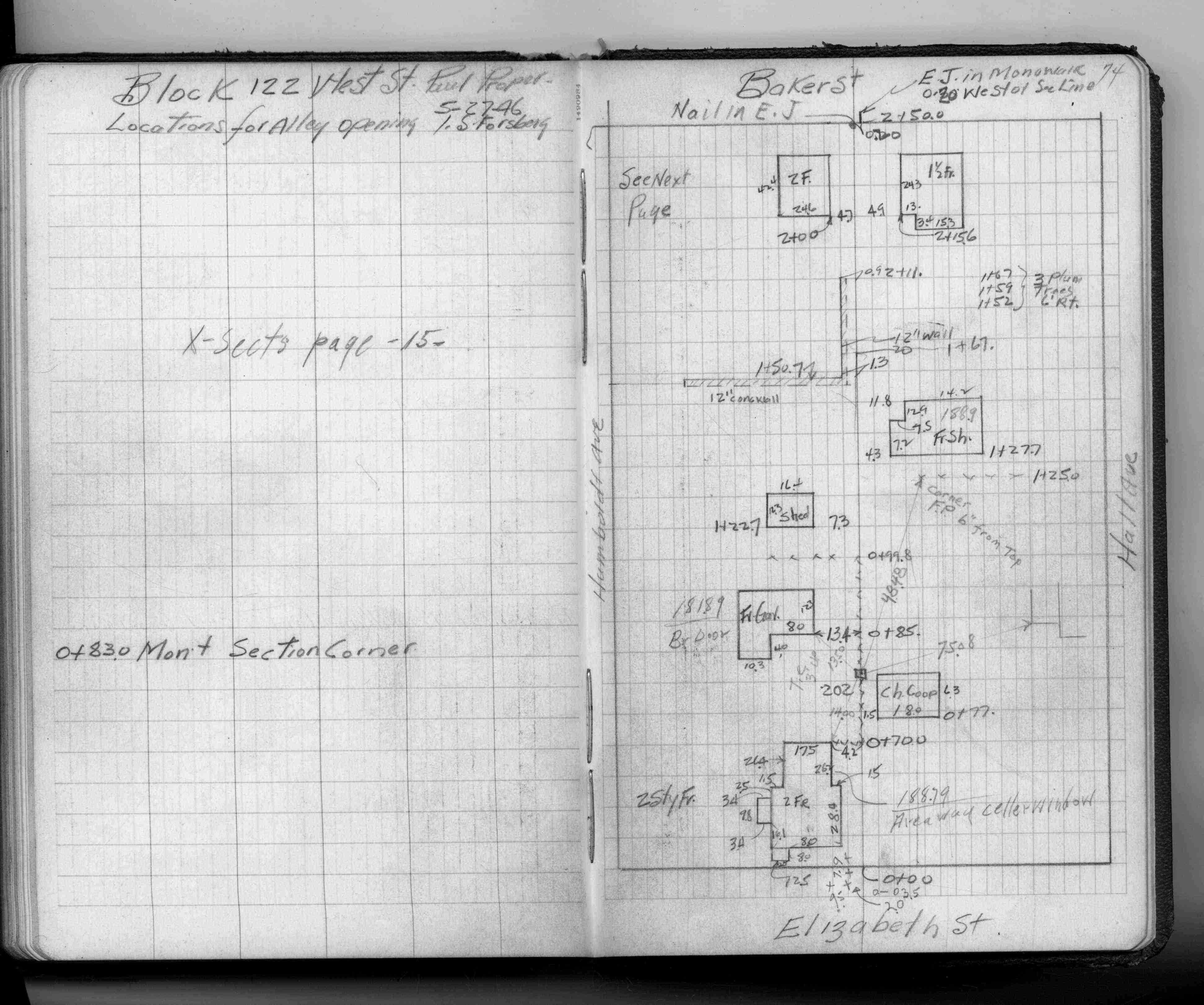
W St Paul Proper Alley B122
FROM
Elizabeth St
TO
Baker St
| Locations | 1946-05-27
74
75
Page(s) 76
Arundel St
FROM
Arlington Ave
TO
South
| House Location | 1946-10-12
76
Page(s) 77
Unknown Location
FROM
Unknown
TO
Unknown
| Bench Marks | 0000-00-00
77
Page(s) 78-79
Unknown Location
FROM
Unknown
TO
Unknown
| Calculations & Elevs | 0000-00-00
78
79