Page(s) 1
Blank Page
FROM
Blank
TO
Blank
| Blank | 0000-00-00
Page(s) 2
Wabasha Bridge
FROM
Station 1+00
TO
Station 11+44.5
| Locations | 0000-00-00
2
Page(s) 3
Blank Page
FROM
Blank
TO
Blank
| Blank | 0000-00-00
Page(s) 4
Boat Slips Near Wabasha Bridge
FROM
Station 3+88
TO
Station 9+00 (44 ft deep)
| Locations & depth | 0000-00-00
4
Page(s) 5-7
Wabasha Bridge
FROM
Station 2
TO
Station 11+50
| Cross Sections | 1954-08-20
5
6
7
Page(s) 8
Near Wabasha Bridge
FROM
Moses St (Vac) & Water St
TO
Navy Island
| Bench Marks | 0000-00-00
8
Page(s) 9-12
Wabasha Bridge
FROM
Station 0-25
TO
Station 11+50
| Cross Sections | 0000-00-00
9
10
11
12
Page(s) 13-14
Unknown Location
| Locations | 0000-00-00
13
14
Page(s) 15
Blank Page
FROM
Blank
TO
Blank
| Blank | 0000-00-00
Page(s) 16-18
W Bank River Channel
FROM
Station 0-100 (On Revtment)
TO
Floor Naval Aromory
| Cross Sections | 0000-00-00
16
17
18
Page(s) 19
Blank Page
FROM
Blank
TO
Blank
| Blank | 0000-00-00
Page(s) 20
CGW RR Pier @ Mississippi River
| Pier Deminsions | 0000-00-00
20
Page(s) 20
Robert St Br Pier @ River
| Pier Deminsions | 0000-00-00
20
Page(s) 21
Blank Page
FROM
Blank
TO
Blank
| Blank | 0000-00-00
Page(s) 22
Old Robert St Bridge Pier
FROM
Missisippi River
| Pier Deminsions | 0000-00-00
22
Page(s) 23
Blank Page
FROM
Blank
TO
Blank
| Blank | 0000-00-00
Page(s) 24-25
Mississippi River
FROM
Sewer Headwall
TO
Station 17+0
| River Elevations | 1954-09-15
24
25
Page(s) 26-31
Mississippi River West Bank
FROM
Robert St Bridge
TO
600 ft upstream
| Locations & X-Secs | 1954-09-00
26
27
28
29
30
31
Page(s) 32-37
Mississippi River West Bank
FROM
Robert St Bridge
TO
650 ft upstream
| Soundings & X-Secs | 1954-09-24
32
33
34
35
36
37
Page(s) 38-39
Riverview Add Sewer Alley B1
FROM
Woodlawn Ave
TO
450 ft North
| Locations & Levels | 1954-12-13
38
39
Page(s) 40
St Anthony Park North L17 & L18 B50
FROM
Station 0+40 (Raymond & Scudder)
TO
Station 0+03
| Tree Locations | 0000-00-00
40
Page(s) 41
Maryland Ave & Hazelwood St
| Locations | 1955-02-01
41
Page(s) 42-43
Ruth St
FROM
Hoyt Ave
TO
298 South Larpenteur Ave
| Sewer Profile | 1955-03-02
42
43
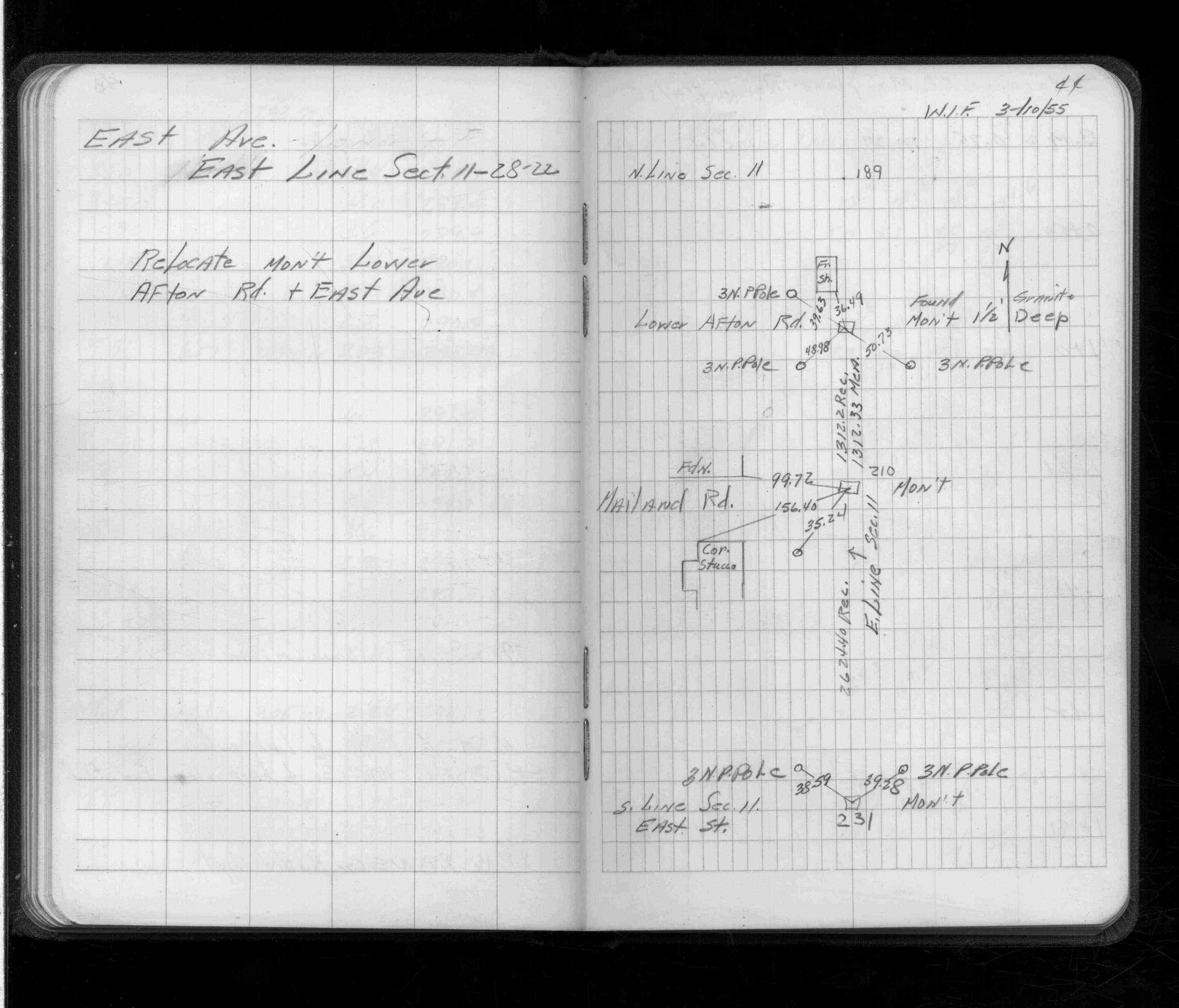
Page(s) 44
East Ave (McKnight Rd) & Mailand Rd
| Monument Locations | 1955-03-10
44
Page(s) 45-47
Clarence St
FROM
Maryland Ave
TO
North 232 ft
| Cross Sections | 1955-04-14
45
46
47
Page(s) 48-49
Small Boat Harbor
FROM
Station 11+50
TO
Going East to Station 6+60
| Soundings | 1955-04-22
48
49
Page(s) 50-52
Boat Launching Ramp
FROM
Station 0+00
TO
Station 1+565
| Locations & X-Secs | 1955-04-27
50
51
52
Page(s) 53-56
Small Boat Harbor
FROM
Wabasha St
TO
Station 11+50
| Cross Sections | 1955-05-23
53
54
55
56
Page(s) 57-60
Near Pavillion (Harriet Island)
FROM
Harbor Line (End of Revet.)
TO
Station 13+0 (River)
| Elevs & X-Secs | 1955-06-03
57
58
59
60
Page(s) 61-62
Unknown Location
FROM
RR Spk Arc Lite Pole NE Pav
TO
US BM Top Swr Headwall
| Cross Sections | 1955-06-20
61
62
Page(s) 63
Revetment&Swr Headwall
| Location | 1955-07-19
63
Page(s) 64-65
Pacific St
FROM
Hazelwood St
TO
1500 ft West
| Levels | 0000-00-00
64
65
Page(s) 66-67
Proposed Parking Lot
FROM
West of Pavillion (Harriet Island)
| Profile & CBs | 1956-05-16
66
67
Page(s) 68-70
Harriet Island Roadway
FROM
Sta 10+26 (Begin Curve)
TO
Headwall
| Cross Sections | 1956-06-01
68
69
70
Page(s) 71-73
Clear Ave
FROM
White Bear Ave
TO
West 300 ft
| Sidewalk Locations | 0000-00-00
71
72
73
Page(s) 74
Page Voided
FROM
Void
TO
Void
| Void | 0000-00-00
74
Page(s) 75-80
Near Louise & White Bear Aves
| Profiles & X-Secs | 0000-00-00
75
76
77
78
79
80